
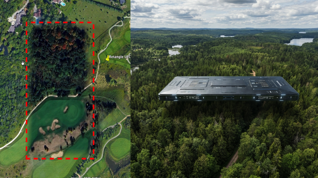
Source-provided UFO Sightings Daily image from the Google Earth shadow claim. It is source media, but it is not independent proof of a craft.
Source video embedded from UFO Sightings Daily. The clip illustrates the claim and should be read as source context, not verified evidence.
The short version
UFO Sightings Daily highlights a Google Earth image in Canada where a rectangular shadow over trees and a golf course is measured by the source at roughly 300 meters by 150 meters.
The source interprets the shape as a possible cloaked craft casting a shadow and compares the claimed scale to the 2008 Stephenville, Texas rectangle-UFO reports. The concrete facts are narrower: a Google Earth coordinate, a visible rectangular shadow-like feature, a claimed measurement, and a source video showing the image lead.
What the report says
The post gives the discovery date as August 6, 2026, the location as Canada, and the Google Earth coordinates as 43°31'18.26"N, 80°28'39.45"W. It says the feature appears over trees and a golf course and that Google’s ruler tool put it at more than 300 meters across and about 150 meters wide.
The author argues that a cloaked UFO could still block sunlight and create a shadow, then links that interpretation to earlier large-rectangle UFO accounts. That interpretation remains speculative; the source does not establish altitude, object presence, image date, aircraft traffic, cloud-shadow conditions, terrain, or Google Earth compositing artifacts.
Media analysis and limits
The source image and video are useful because they preserve the exact claimed visual feature and coordinates. The monitor can revisit the spot, compare imagery dates, and check whether the same shape appears in alternate satellite layers.
The limits are significant. A rectangular dark patch in satellite imagery can have many causes: shadow from clouds or structures, image seams, processing artifacts, terrain/vegetation contrast, or temporary ground conditions. The source’s alien-craft conclusion is not supported by independent evidence in the article.
Why this one is worth tracking
Google Earth discovery claims are common in UFO channels and often spread quickly because they are easy for readers to inspect. Tracking the strongest version of the claim, with coordinates and source media, lets The UAP Trail separate verifiable image facts from unsupported conclusions.
This item is also a useful companion to older rectangle-object cases: it shows how a visual similarity can be interesting without being proof that two different reports share the same cause.
Open questions
What is the imagery date for the Google Earth layer at 43°31'18.26"N, 80°28'39.45"W?
Does the rectangular feature appear in other satellite providers, historical Google Earth frames, or only one composited image layer?
Can local terrain, golf-course structures, clouds, or image-processing seams explain the feature before any exotic hypothesis is considered?