
Source-image lead
Black Sea seabed-image lead: claimed underwater structure enters source archive watch
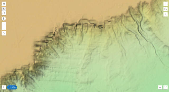
The latest item added to the monitor is not a confirmed craft report. It is a source-image lead: UFO Sightings Daily points readers to a Seabed 2030 map view near roughly 90 miles out into the Black Sea and argues that a seafloor pattern may be artificial. The useful record is the map-source claim, the posted image, and the need for coordinates and bathymetric review — not the source author’s alien-origin conclusion.
The short version
UFO Sightings Daily published a Sept. 8, 2026 source post about a seafloor feature described as being roughly 90 miles out into the Black Sea. The post identifies Seabed 2030 as the map source and includes still imagery plus a video. This monitor entry keeps the observation narrow: a public map image appears to show a feature that the source author interprets as artificial.
What the report appears to explain
The concrete report is limited. According to the source post, the source author says a seabed-map feature shows finger-like structures, with one interpreted span described as more than 10 miles long and about 3 miles wide. The article points to Seabed 2030 as the underlying map project and publishes a still image and video walkthrough of the claimed feature.
Claims that the feature is an ancient alien base, Eden, Anunnaki-linked, hundreds of thousands of years old, or evidence of recoverable alien technology are the source author's interpretation, not evidence established by the map image alone.
Media analysis and limits
The media is useful as a lead, not as proof. A seafloor-map screenshot can be affected by survey resolution, stitching, sonar coverage, interpolation, compression, slope shading, labels, and display settings. Without exact coordinates, raw bathymetric data, survey-line context, and a qualified geological or hydrographic review, the monitor cannot distinguish an artificial structure from natural terrain, mapping artifacts, or data-processing effects.
Why this one is worth tracking
This lead is worth tracking because it names a map source and publishes source imagery that can be checked later against coordinates, independent map layers, and any public seabed-survey metadata. It also shows why speculative UAP-adjacent image claims need careful handling: the reader should see what was claimed while the unsupported leap to alien construction remains clearly separated from the evidence.
Open questions
- What are the exact coordinates of the claimed feature?
- Which survey data, resolution, and processing pipeline produced the Seabed 2030 view?
- Do independent bathymetric or nautical charts show the same shape?
- Could slope shading, sonar-track seams, interpolation, or coastline-collapse geology explain the visible pattern?
- Has any qualified marine geologist, hydrographer, or archaeology team reviewed the claim?